

Larissa Fedunik
23 April 2024: Researchers at the University of Canberra’s Centre for Applied Water Science (CAWS) have completed their second year of a drone-based vegetation monitoring project to map the response of tangled lignum to environmental water management in the Mallee Catchment near Mildura, Victoria. The project demonstrates the accuracy of drone-based monitoring compared to ground surveys and underscores the value of environmental water in improving the condition of tangled lignum.
The research is funded by the Mallee Catchment Management Authority (CMA), Victoria, and has now been adopted across other Commonwealth and state-funded environmental water monitoring and evaluation programs.
Tangled lignum – or simply, lignum – is the main floodplain and wetland shrub species in the Murray-Darling Basin. Its tangled branches provide a nesting habitat for native waterbirds such as the straw-necked ibis.
Although lignum is highly tolerant of drought, it is currently a target for environmental water (ewater) management. Ewater encapsulates various water management strategies, which involves the use of pumping infrastructure and creating overbank floods.
“Lignum is a very ecologically important plant species, which is why we want to know that the lignum patches are healthy and functioning,” said lead researcher, plant ecologist and Research Fellow Will Higgisson.
Over 2019-2021, Dr Higgisson led a similar drone-based monitoring project of wetland reed beds at the end of the Lachlan River system in New South Wales, which was funded through the Commonwealth Flow-Monitoring, Evaluation and Research (MER) program.
“Because of its success, this approach was picked up by the Victorian Government, who has now funded the lignum project,” said Dr Higgisson.
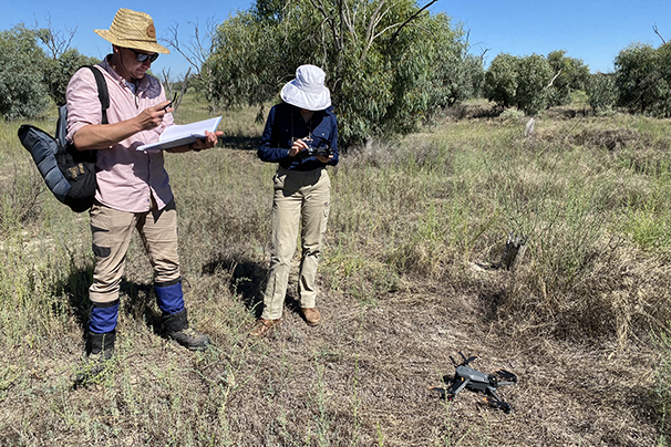
The current method of assessing lignum is a ground-based field survey that involves surveying plants in selected plots and assessing the lignum condition and coverage. Not only is this process labour intensive, it can also be difficult to access plants in floodplains.
To address these challenges, Dr Higgisson and colleagues Dr Rui Liu, Adrian Cobb, Alica Tschierschke and Professor Fiona Dyer are using aerial drone imagery to map the lignum in the Mallee Catchment. After developing and testing machine learning models of the lignum, they can then assess its response to ewater.
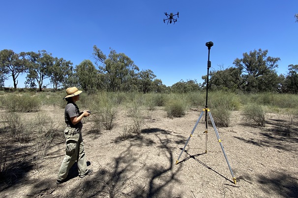
For each site survey, the team fly two types of drones across selected 50 square metre plots, capturing about 140 high-resolution photographs per plot.
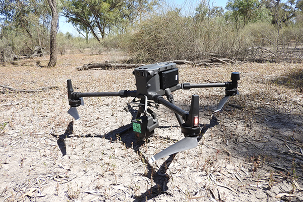
The first type of drone is a small, off-the-shelf model equipped with a red-green-blue (RGB) camera. The camera is accurate enough to classify the lignum into two condition classes: green (high quality) and brown (low quality).
The second drone is custom-fitted with a LiDAR (Light Detection and Ranging) camera. LiDAR uses laser beams to create a 3D representation of a surveyed environment, meaning that the shape, size and height of the plants can be captured.
The images are pre-processed into a single high-resolution image for each site, then used to build and test a machine learning model. The model sorts the images into categories, including green and brown lignum, water, bare ground and other plants. The researchers then manually sort the images, adding, removing or combining categories to improve the model’s performance.
After feeding the images back into the model, a deep learning model, optimised by the research team, takes charge.
“Deep learning basically goes through those thousands of image slices and uses them to learn everything that it possibly can about lignum,” explained Dr Higgisson.
When tested, the final model achieved an accuracy of about 90 per cent, which is comparable to state-of-the-art literature for this emerging technology.
Dr Higgisson and his team have now evaluated 18 lignum sites in the Mallee Catchment over two years.
They found that the sites managed with ewater have the highest coverage of high quality lignum. For example, the ewater-managed Hattah Lakes site was found to contain 40.3 per cent high quality lignum, while an unmanaged site only contained 17.1 per cent.
“This shows that drones and machine learning can provide meaningful data that can inform the use of environmental water,” says Dr Higgisson.